


Hot, humid, and rainy across Central Indiana

INDIANAPOLIS (WRTV) —
Sunday night: A few showers and thunderstorms may linger this evening, then activity becomes more isolated overnight. Lows hold near 70, with a light southeast breeze around 5 mph. It stays warm and sticky through the night, and any storm that does hold together could still drop a quick heavy downpour.
Monday: Mostly cloudy, humid, and unsettled with scattered showers and thunderstorms developing, especially in the afternoon. Highs reach around 80, with a light south to southeast breeze around 5 to 10 mph. This looks like one of the wetter and less reliable days for daytime plans, and a few storms could bring localized flooding downpours.
Monday night: Showers and thunderstorms remain possible through the evening and overnight under mostly cloudy skies. Lows stay near 70, with a light south breeze around 5 mph. It will not rain all night everywhere, but roads could stay wet at times and the muggy feel does not go anywhere.
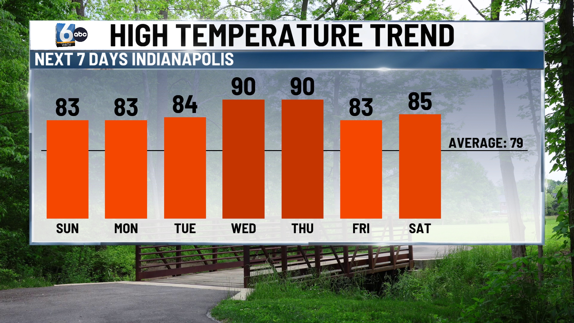
Tuesday: Mostly cloudy, humid, and still active with another round of showers and thunderstorms possible. Highs recover into the mid 80s, with a southwest breeze around 5 to 10 mph. Some of the storms could produce heavier rain, so this is another day where outdoor schedules may be harder to trust.
Tuesday night: Showers and thunderstorms continue through the evening, then coverage eases back somewhat later at night. Lows settle in the low 70s, with a light southwest breeze around 5 mph. The air stays very humid overnight, and any heavier cell could still cause ponding on roads and reduced visibility.
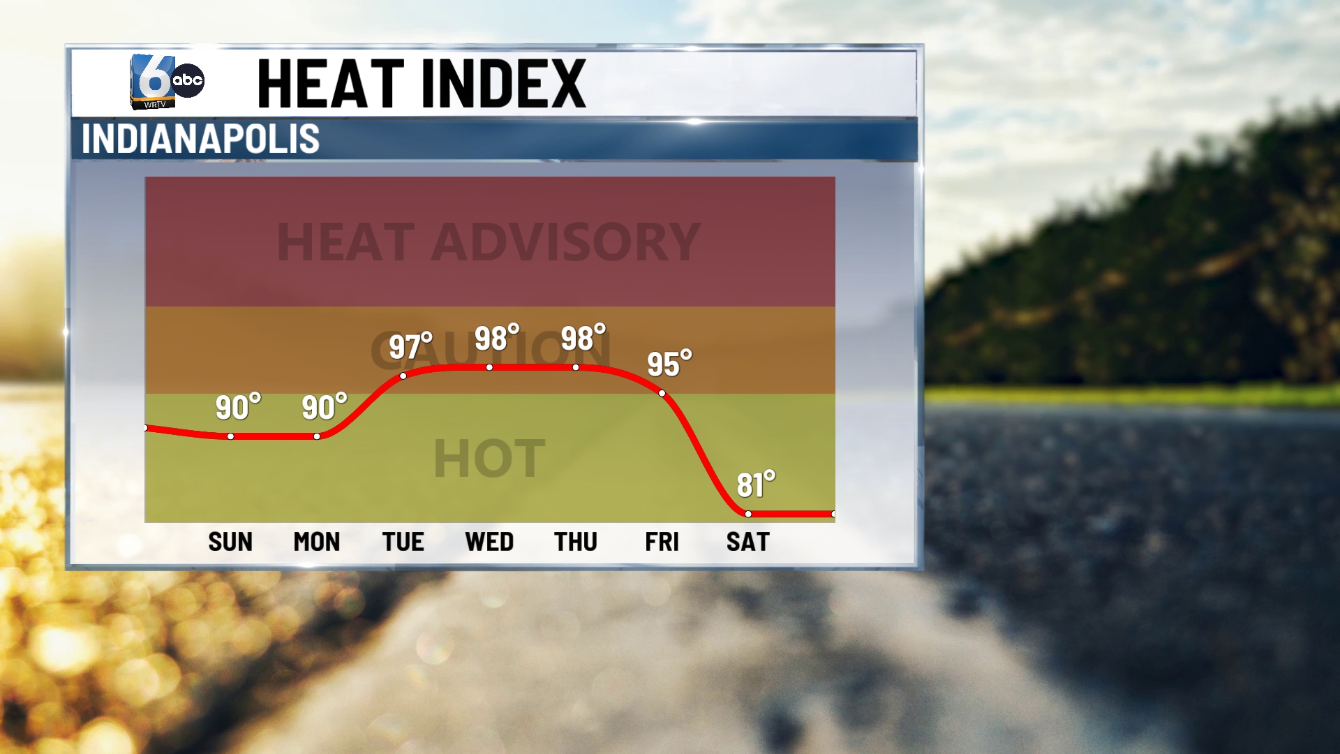
Wednesday: Very warm and very humid with mostly cloudy skies and another chance for showers and thunderstorms. Highs reach the upper 80s, with a light southwest breeze around 5 to 10 mph. Compared with Monday and Tuesday, heat becomes a bigger factor, even if rain is not constant from start to finish.
Wednesday night: Partly to mostly cloudy, warm, and muggy with a slight chance for a leftover shower or storm. Lows only fall into the mid 70s, with a light south breeze around 5 mph. It is another summerlike night with very little cooling.
Thursday: Very warm and humid with periods of clouds and sunshine, plus another chance for afternoon thunderstorms. Highs push near 90, with a light southwest breeze around 5 to 10 mph. This looks like the hottest day of the stretch, and any storm that develops could still produce a quick downpour.
Thursday night: Partly cloudy, muggy, and mild with a slight chance for an evening thunderstorm. Lows settle near 70, with a light southwest breeze around 5 mph. The sticky air stays in place into the end of the workweek.
7 day outlook: The pattern stays much more humid and unsettled through the workweek, with daily chances for showers and thunderstorms and the better coverage favored Monday and Tuesday. Temperatures stay above normal the whole way, with highs around 80 Monday, mid 80s Tuesday, upper 80s Wednesday, and near 90 Thursday.
The main concern is not nonstop rain, but repeated rounds of storms and locally heavy downpours interrupting otherwise hot, muggy weather before slightly cooler conditions arrive next weekend.
