


Winter weather has arrived, but it's only here for a limited time.
We should see a lull in snow showers for much of the night. In fact, skies may become partly cloudy for a time. Winds stay breezy with temperatures falling into the middle 20s.
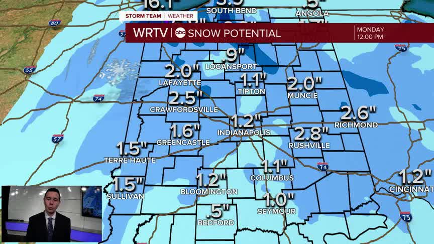
Overnight into Monday morning, a swath of snow is expected to sweep from north to south across Central Indiana. The timing isn't great as it could impact the morning drive with low visibility and slick spots on the roads/sidewalks. A Winter Weather Advisory is in effect for much of Central Indiana, including Indianapolis, until 10AM. Snowfall amounts will range from a coating south to 1"-2" north. Some isolated higher totals aren't out of the question.

Wind gusts around 25 mph make an already cold day feel even colder. Wind chills in the teens Monday morning mean everyone will need to bundle up! Feels like temperatures only get into the 20s during the afternoon.

Most of the snow should end by the middle of the day. Some clearing will lead to a brighter afternoon, but it stays cold. The last time we had highs only reach into the 30s was March 2nd.

Our weather improves the rest of the week. Highs go from the lower 40s Tuesday to the lower 60s to end the week.
Indianapolis Weather Forecast:
Monday: Light AM snow. Decreasing clouds and breezy. High: 35°
Tuesday: Mostly cloudy and breezy. High: 42°
Wednesday: Mostly sunny. High: 55°
Indianapolis 7-Day Weather Forecast

