

Headlines
- BRIEFLY WARMER WEDNESDAY
- FRIGID TEMPS RETURN FRIDAY
- WATCHING A SOUTHERN STORM SATURDAY
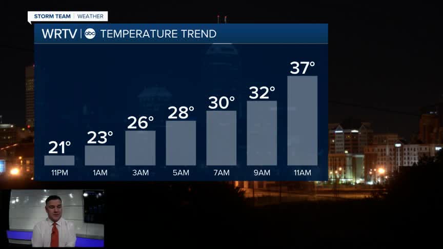
After another bitterly cold day, temperatures will begin to climb overnight, reaching near freezing by daybreak on Wednesday. As the warmer air moves in, some light snow showers will be possible in northern areas, but any accumulation will be very light. Snow showers, and eventually rain showers, may mix in as the front passes through the state during the afternoon; however, any precipitation during this time frame will also be very light.

Thursday will be colder, with temperatures around 30°, before the next arctic blast arrives on Friday. Friday will be a bitterly cold day with dangerous wind chill values. Time spent outside should be very limited.

Some of the wind chill values could approach -30° Friday morning. They get a little better in the afternoon but will not rise above zero, with an actual high temperature of just 14°.

Saturday night, some light snow showers might try to sneak into southern Indiana, but the real heavy snow will stay to the south of Indiana. If you have travel plans south of Indiana, you might want to reconsider.
Indianapolis Weather Forecast:
Overnight: Mostly cloudy. Snow showers north. Low: 23° (slowly climbing)
Wednesday: Warmer. Mostly cloudy with a few rain/snow showers High: 40°
Thursday: Partly cloudy. High: 30°
Friday: Bitter cold. Partly cloudy. High: 12° (sub zero wind chill)
Saturday: Mostly cloudy. Snow showers south. High: 14°
Indianapolis 7-Day Weather Forecast

