


INDIANAPOLIS (WRTV) - Scattered showers and thunderstorms are possible today. It will nice weekend, but another round of storms will arrive early next week, and some of those could be on the stronger side
TODAY

Cloud cover increases throughout the day today as a system approaches the state. We will see a slight chance for a few scattered showers in the morning. A better chance for some scattered showers and thunderstorms into the afternoon. Some of those thunderstorms in the afternoon could be on the stronger side. We have a level one out of a level five on our severe weather threat scale in place across parts of Indianapolis and the eastern part of the state as well. No to threat, but there is a threat of some gusty winds and moderate to heavy rainfall at times as well. High temperatures will climb near 77 degrees. Winds will be a bit breezy again out of the south and southwest they could gust near 25 mph.
TONIGHT

Scattered showers and thunderstorm as possible this evening with an isolated severe storm. Low temperatures will fall near 50
TOMORROW

Dry conditions throughout the weekend. Look for lots of sunshine on Saturday. It will be a bit cooler with high temperatures near 74. But still above our normal high of 67.
7 DAY EXTENDED FORECAST
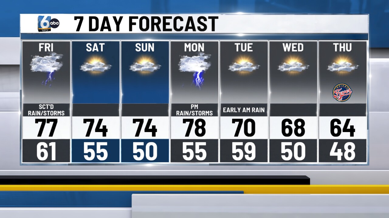
Dry conditions to end the weekend. Look for mostly sunny skies on Sunday with highs near 74.
A system approaches on Monday. This will bring us a good chance of some showers and thunderstorms later in the afternoon and evening. Some of the thunderstorms on Monday could be on the stronger side and old severe weather modes will be in play. Look for high temperatures into the upper 70s. A few lingering showers early Tuesday morning. Otherwise drying out for your Tuesday afternoon. The high temperature is close to 70. And then for the bid and ladder half of the week temperatures return closer to normal and maybe even dipping below normal at times on Thursday.
