


Headlines
- WARM AND DRY WEATHER CONTINUE INTO OCTOBER
- 15° - 20° ABOVE NORMAL THIS WEEKEND
- NEXT CHANCE OF RAIN IS TUESDAY
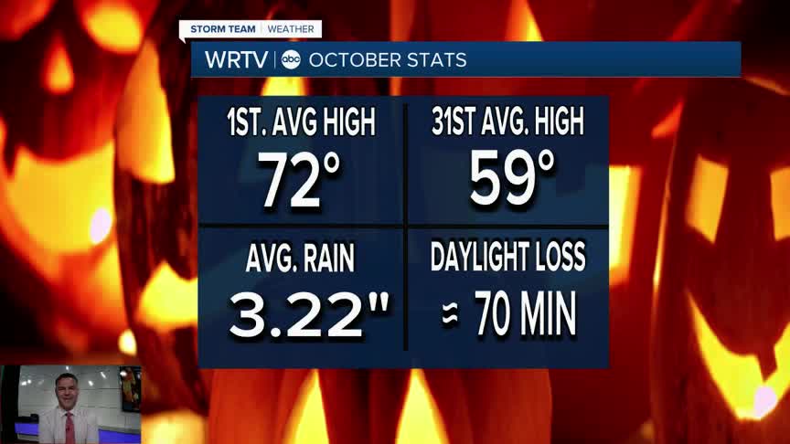
The new month brings a continuation of the weather we experienced for much of September: dry and warm. However, October as a whole is a month that brings a lot of change to the area. Daylight continues to decrease, with the state losing about 70 minutes of daylight on average. It’s also the month when we begin tracking monthly snowfall averages again. While the average is only 0.1", it’s a sign of things to come. Another notable trend is that October features one of the biggest declines in average high temperatures. The average high drops from 72° on the first to 59° on the 31st.
Thursday will bring partly cloudy skies to the area, with temperatures beginning a warming trend as we head into the end of the week. Highs on Thursday will climb into the mid-80s, putting us about 10° to 15° above normal.

The warming trend will peak on Saturday, with high temperatures close to 90°.

Early next week, a cold front will bring a chance of rain to the area on Tuesday. It won’t be a drought-buster, but it will provide an opportunity to get the ground wet. Once the front passes, we’ll return to more seasonable temperatures by the middle of the week.
Indianapolis Weather Forecast:
Overnight: Partly cloudy Low: 56°
Thursday: Partly cloudy High: 84°
Friday: Mostly sunny. High: 86°
Saturday: Mostly sunny. High: 87°
Indianapolis 7-Day Weather Forecast

