


Headlines
- WATCH FOR REFREEZING OVERNIGHT
- WARMING TREND INTO NEXT WEEK
- WELL ABOVE NORMAL NEXT WEEK
Overnight, temperatures will drop below freezing once again, which could result in some refreezing and black ice. The good news is that we didn’t see as much melting today, so it shouldn’t be as big of a problem, but it’s still wise to be a bit cautious.

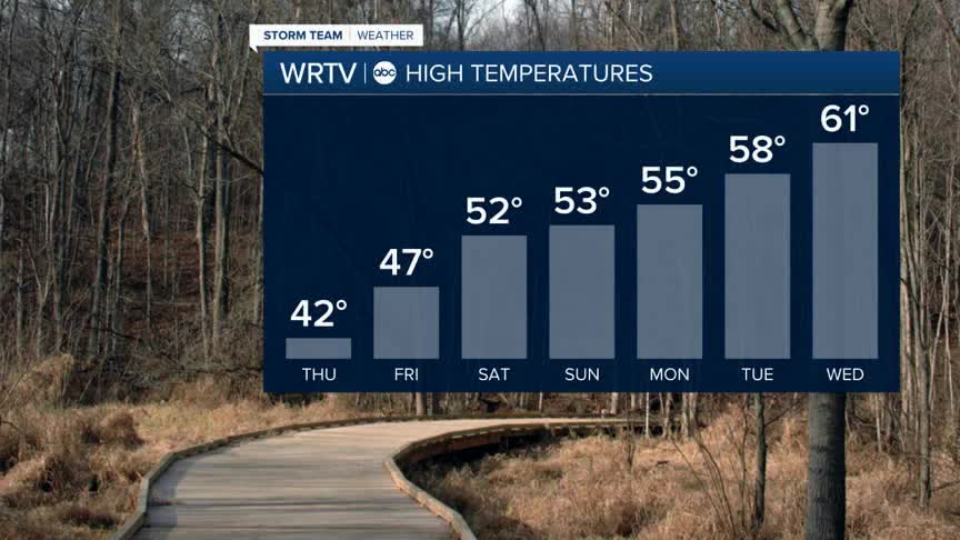
Skies on Thursday will be partly sunny across the area, with a period of overcast conditions as a weak front moves through. A flurry or sprinkle can’t be ruled out, but nothing major or troublesome is expected. Highs will top out in the low 40s.

On Friday and through the weekend, temperatures will start to climb. Expect upper 40s with sunshine on Friday, rising into the low 50s on Saturday for Valentine’s Day, and then reaching the mid 50s on Sunday. We’ll be watching a storm to our south Saturday night into Sunday that may try to bring some showers in. The bulk of the rain will stay south, but depending on the exact track, we might have to bring some rain showers into southern Indiana.

The best news is that the Climate Prediction Center put out its 8–14 day outlook today. From February 19th to 25th, we are looking at above-normal temperatures throughout the Midwest and Deep South. Temperatures in the 60s are certainly possible for us during that timeframe.
Indianapolis Weather Forecast:
Overnight: Partly cloudy. Low: 25°
Tomorrow: Partly sunny High: 42°
Friday: Mostly sunny. High: 47°
Saturday: Sun & clouds. High: 52°
Sunday: Partly cloudy - Shower chance. High: 53°
Monday: Sun & clouds. High: 55°
Indianapolis 7-Day Weather Forecast

