


Headlines
- BITTER COLD WIND CHILL VALUES FRIDAY
- SNOW ARRIVES SATURDAY AFTERNOON
- SIGNIFICANT ACCUMULATIONS FOR MOST
Before we talk about snow, let's discuss some dangerously cold wind chill values heading our way for Friday. A Cold Weather Advisory is in effect for the northern half of the area, where wind chill values may be as low as -25° during the morning. Outside of the advisory area, wind chill values will also be below zero. No matter where you are, make sure to bundle up throughout the day. It will be a dry day, with no snow in the forecast. Numerous schools already have E-Learning days, 2 hour delays or cancellations so make sure you check before you bundle up and head out.

Some snow showers will develop Saturday morning in southern locations. It may take a bit longer for the snow to start in northern areas due to a lot of dry air in place. For those north of Indy, the snow really won't get going until Saturday evening. Saturday morning plans should be just fine. Conditions will deteriorate throughout the afternoon from southwest to northeast. The brunt of the storm will arrive late Saturday into the overnight hours of Sunday morning.

Here are your headlines for the storm.

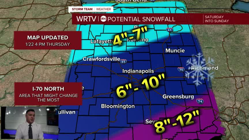
If the models hold, most of the area will see about 6–10" of snow. Some higher totals will be possible in southern locations, while totals to the north will be a bit lower. However, it will be very cold, so whatever falls will stick quickly and roads will be snow-covered no matter where you live. Wind won't be a major factor, but this will be a light and fluffy snow, so any breeze we do have will result in some blowing and drifting. Here is a map of projected snow totals.

More updates will come tonight and tomorrow as the storm develops. There are also some indications that sleet might try to mix in across southern locations, which could impact snow totals. It’s not a major threat yet, but some models are suggesting this possibility. Below is a map of the Winter Storm Watch and Warning. More counties will likely be upgraded to a warning tomorrow.

Indianapolis Weather Forecast:
Overnight: Bitter cold. Partly cloudy Low: 6°
Friday: Partly cloudy. Brutal wind chill values. High: 11° (sub zero wind chill all day)
Saturday: Snow develops. High: 12°
Sunday: Snow. Heaviest in the morning. High: 15°
Indianapolis 7-Day Weather Forecast

