


Headlines
- NO WHITE CHRISTMAS
- MILD BUT GLOOMY CHRISTMAS DAY
- MUCH COLDER NEXT WEEK
CHRISTMAS EVE
Overall, it will be a mostly cloudy but mild day. However, if you are gathering with family and friends in the evening hours, look for some very light and spotty showers to develop, continuing into Christmas morning. Fog will also be possible.

CHRISTMAS DAY
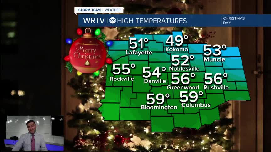
There will be a significant temperature spread across the area. Earlier in the week, it appeared that the warm front would push well into Indiana. However, it now looks like that front will stay south of I-70, so I’ve adjusted the temperatures down slightly. That said, we will still be well above normal for everyone, with southern locations running much warmer.
It will be a rather gray day for us, with plenty of clouds, some fog, and showers in the morning as well. With the clouds lingering, there won’t be much warming or cooling throughout the day

Here is bit of an idea on how warm it will be in your communities.

The cold front will arrive Sunday as temperatures drop and then it is back to bitter cold temperature to start next week.

Indianapolis Weather Forecast:
Overnight: Mostly cloudy Low: 33°
Christmas Eve: Mostly cloudy. Showers late. High: 54°
Christmas Day: Morning Fog & Showers. Then Cloudy. High: 56°
Friday: Showers early. Mild. High: 64°
Saturday: Mostly cloudy. High: 63°
Indianapolis 7-Day Weather Forecast

