


Headlines
- PLEASANT, SUMMER-LIKE WEDNESDAY
- RAIN & THUNDERSTORMS RETURN THIS EVENING/OVERNIGHT
- COOLER TEMPERATURES STARTING THURSDAY
Changes are on the way - rain and cooler temperatures - but before we get there, enjoy a pleasant, summer-like forecast Wednesday. A few more clouds build in as the afternoon and evening progress. Temperatures are near normal level in the low 80s. This is the last day temperatures climb into the 80s through the 7-Day Forecast.

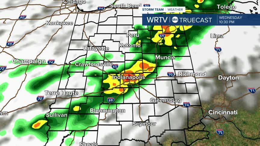
After the evening commute, rain and thunderstorms move through Central Indiana. Rain will start in the northwest portion of the state, and gradually push southeast. No severe weather is likely, but gusty winds and downpours are possible. Rain and storms continue into the overnight hours.

A few showers could linger into early Thursday morning, but most of Thursday is dry. Clouds break by the afternoon. Temperatures are noticeably cooler, with highs struggling to reach 70° tomorrow.

Highs warm to the mid 70s Friday. Friday looks mostly dry, but by Friday evening, a few rain showers are possible, especially for areas south of Indianapolis.

We dry out this weekend. It should be pleasant with sunny skies Saturday and Sunday, although high temperatures remain below normal in the low 70s.
Indianapolis Weather Forecast:
Today: Mostly sunny. PM clouds and evening rain/thunderstorms. High: 83°
Overnight: Rain/thunderstorms. Low: 59°
Thursday: Showers end early. Clouds clearing. Cooler. High: 70°
Friday: Mostly sunny. Few evening rain showers. High: 75°
Indianapolis 7-Day Weather Forecast

