


Headlines
- RAIN CHANCES THIS EVENING FAR WEST
- ISOLATED STORMS CHANCES TUESDAY & WEDNESDAY
- HEAT & HUMIDITY BUILD LATE WEEK
If you have plans this evening, most of us will remain dry. However, far western areas, including and around Terre Haute, have received several inches of rain and will continue to experience rain chances throughout the evening. Temperatures will stay in the 70s for most of the evening.

Scattered storm chances will persist on both Tuesday and Wednesday. Aside from the occasional storms, we can expect partly cloudy skies and temperatures returning to the low to mid-80s. Don't cancel any outdoor plans you may have due to the rain chances.

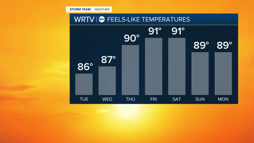
Rain chances will end by Thursday, and then we will turn our attention to the heat and rising humidity levels. While it's not a repeat of earlier in the summer, heat index values will reach the low to mid-90s by the time we get to the weekend.

Actual temperatures will be in the upper 80s. Storm chances look low from Thursday through Saturday before picking back up on Sunday and continuing into the start of next week.
Indianapolis Weather Forecast:
Overnight: Partly cloudy - A few showers Low: 66°
Tuesday: Partly cloudy - Spot showers High: 85°
Wednesday: Mostly sunny. Spot Shower. High: 86°
Thursday: Mostly sunny. More humid. High: 88°
Indianapolis 7-Day Weather Forecast

