


Headlines
- CLOUDY BUT MOSTLY DRY TUESDAY
- RAIN RETURNS TONIGHT
- ADDITIONAL RAIN CHANCES THROUGH END OF WEEK
- SUNSHINE RETURNS THIS WEEKEND
This aftertoon is cloudy, but the day itself should stay rain-free. High temperatures will try to warm into the upper 70s this afternoon.

Most of your evening plans should be uninterrupted by rain this evening. However, a few showers are possible this evening in North Central Indiana.

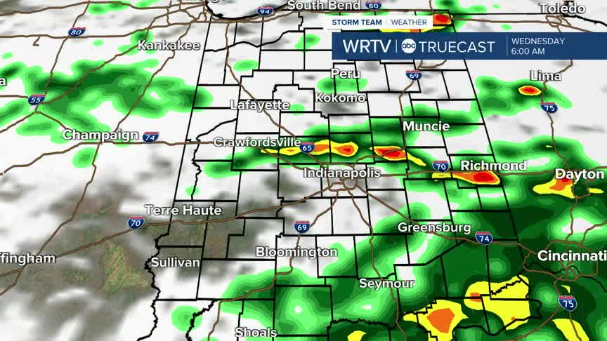
Another system moves into the area overnight, so rain becomes more widespread by early Wednesday morning. Have an umbrella ready to go tomorrow out the door.

Wednesday morning is the rainiest time of the day. Some downpours and thunderstorms are possible. Rain showers are more scattered in the afternoon with highs in the low 70s.

After a few more shower chances Thursday, we'll dry out and see some sunshine as we head into the weekend. Temperatures will be warmer than normal this weekend, with highs climbing near 80°.
Indianapolis Weather Forecast:
Today: Mostly cloudy. Rain chance late. High: 80°
Overnight: Scattered rain & thunderstorms. Low: 66°
Wednesday: Scattered rain showers. Thunderstorm possible. High: 73°
Indianapolis 7-Day Weather Forecast

