


Headlines
- GUSTY WIND TUESDAY
- FROST POSSIBLE THURSDAY & FRIDAY MORNING
- NEXT RAIN CHANCE WILL BE OVER THE WEEKEND
A weak cold front will pass through overnight, bringing just a slight chance of a few sprinkles—most of us won’t even see them. It will remain breezy, with temperatures in the upper 40s across most of the area. While the cold front won’t bring much moisture, it will open the door to stronger wind gusts again on Tuesday.

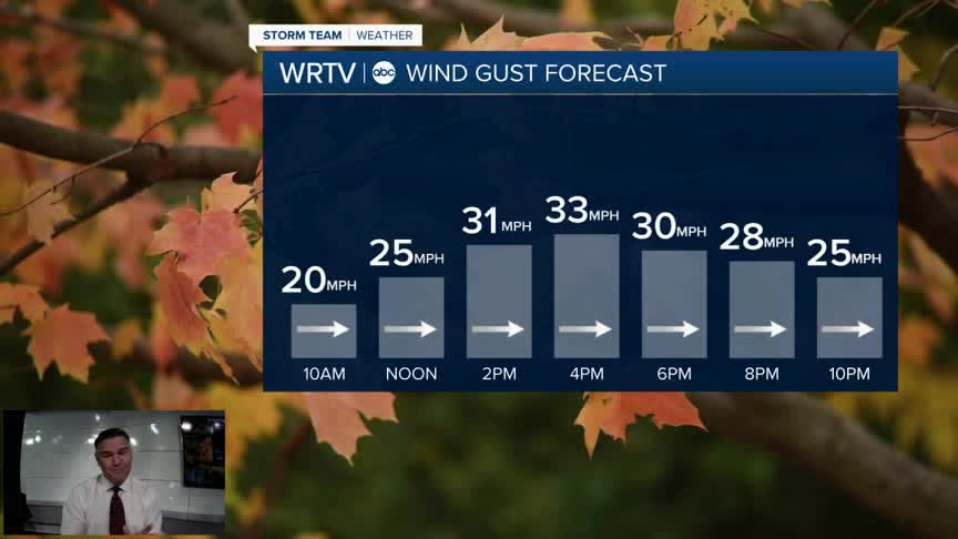
We’ll start the day on the cool side but end with temperatures in the low to mid-60s, which is seasonable for this time of year. You’ll notice the clouds increasing a bit in the afternoon, and the wind will pick up as the day goes on.

Wind gusts will peak in the mid-30 mph range during the afternoon, then begin to subside once the sun starts to set in the evening.

Looking ahead to the end of the week, it will be fairly nice. However, I do want to alert you to the potential for frost both Thursday and Friday mornings, with Friday being the coldest. It will be chilly no matter what, but whether frost develops will depend on the wind speed.

The afternoons will be fairly pleasant on Thursday and Friday, before rain chances return over the weekend.
Indianapolis Weather Forecast:
Overnight: Spot sprinkle. Breezy. Low: 48°
Tuesday: Gusty winds. Partly cloudy. High: 64°
Wednesday: Partly cloudy. High: 57°
Thursday: Sunny skies. High: 58°
Friday: Partly cloudy. High: 61°
Indianapolis 7-Day Weather Forecast

