


Each year, the biggest question heading into winter is, “How much snow and ice?” While that often grabs the headlines, winter isn’t just about the snow. Temperatures can have a big impact as well—on people, roads, and infrastructure.
In a typical winter, Indianapolis averages 25.5 inches (based on 1991–2020 data) of snowfall. However, there is a very large spread across the state: average snowfall in southern Indiana can be as low as 5 inches, while in northern Indiana it ranges from 30 to 40 inches.

There are many things to consider when making a winter forecast. La Niña and El Niño are probably two terms you have heard before, and they do play a very big role. So do the North Atlantic Oscillation (NAO), the Arctic Oscillation (AO), the Polar Oscillation (PO), as well as data from previous winters. While no two winters are the same, you can look back at history for subtle hints. Considering all the above, the two words that come to mind for our winter in central Indiana are ACTIVE and VARIABLE. Keep in mind, an active winter doesn’t always mean a lot of snow—it could also mean rain and mixed precipitation events.

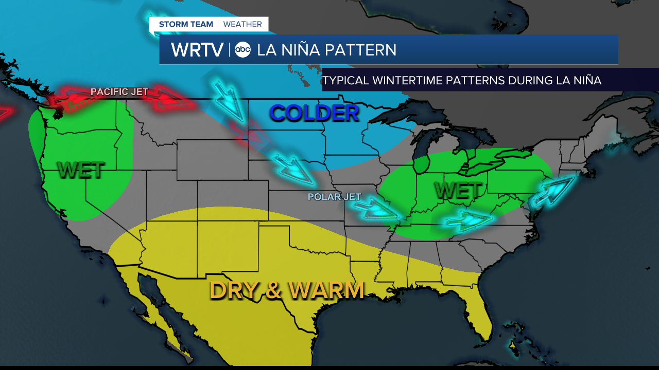
For this winter, a weak La Niña is developing, which will likely fade as the winter progresses to a more neutral state. In this pattern, high pressure builds over the middle of the Pacific Ocean, forcing the jet stream north across the Pacific Northwest, then dipping down and passing close to central Indiana before heading north again across the Northeast .
Once La Niña weakens, the jet stream should flatten out, leading to more of a zonal flow.
The jet stream acts as a highway for transporting storms across the country, and it typically separates arctic air from warmer temperatures in winter. One thing we will have to watch for this winter is the potential to tap into Gulf moisture—this is when we often get our bigger snow totals.
While we will get some moisture from the Pacific, in this pattern the Gulf can be cut off for long periods. Right now, I’m leaning toward more frequent, quick-moving storms with less moisture. That’s not to say we can’t get a bigger storm—that’s certainly possible—but the pattern favors quicker, clipper-like storms, especially earlier in the winter, which would bring more light snow events.
STORM HIGHLIGHTS
- Active through the winter
- More quick-moving storms rather than BIG storms (although those can happen)
- Not all storms will be snow; some mixed events are likely
- Potential for tapping into Gulf moisture
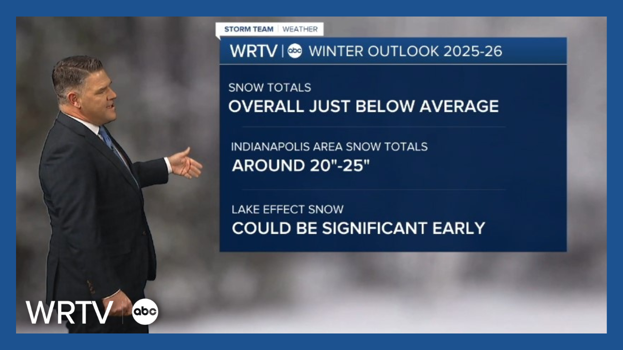
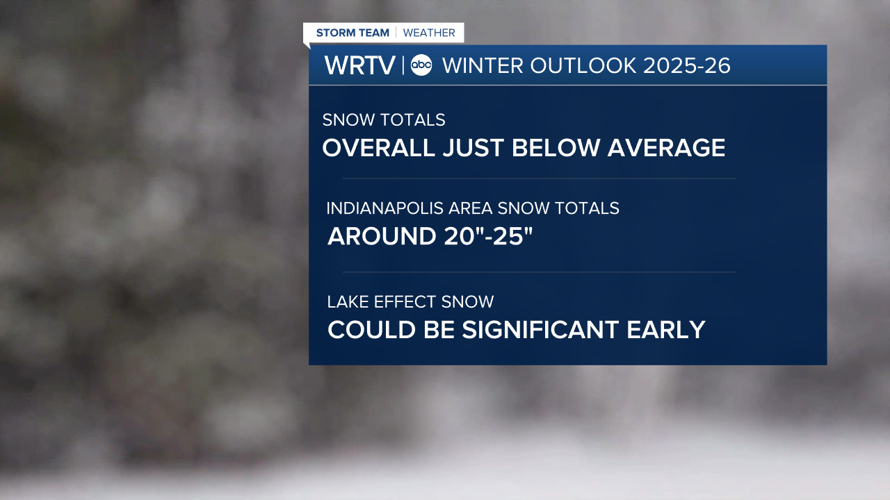
Snow totals just below average: 20”–25” for the Indy Metro Area
Temperatures will likely fluctuate a bit, but overall, it looks like we will run a bit below normal. Looking back at previous years along with the current weather pattern, we will be very prone to arctic outbreaks in early winter while La Niña is in place. The polar vortex looks to be in a favorable position near Hudson Bay in Canada, which could send us some very cold air at times. As winter progresses and La Niña weakens and trends neutral, there might be more variability.
TEMPERATURE HIGHLIGHTS
- Overall, at or just below normal
- Prone to arctic outbreaks. Especially early this winter
- Could see big temperature spreads north to south across the area
- Some tricky ice events possible
One thing to also note is that the Great Lakes water temperatures are running well above normal. With the position of the polar vortex and a north wind coming across Lake Michigan, northwest Indiana will be prone to some significant lake-effect snow. This could significantly increase totals for those in the lake-effect snow belt compared to the rest of the region, at least until water temperatures cool as winter progresses.
Winter weather impacts all of us and will likely bring a variety of challenges at times. The key will be the movement of the jet stream, which should be near Indiana most of the winter.
Stay with WRTV for the latest forecasts as we get through this upcoming winter season together.
